22 Jun 2009
Mapping Ghostsigns
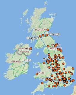
Here’s a neat little thing, all the postcodes in the archive so far plotted onto a map. This gives a really good sense of just how much this is becoming a nationwide project thanks to all the efforts of those submitting their photos to the Flickr group. If you go to the map proper then you can zoom in and check out how many are in your local area.
NB. This is only those signs that I’ve catalogued and researched location information for in the first seven categories of the ghostsigns archive project. I’ll make another one once I get more research done. It is also only the first bit of the postcode so you can’t get it down to street level accuracy as it is. I’ll also look into doing one like that soon but hopefully this gives a good ‘macro’ picture of where we’re at.
The map was created using the ‘batchgeocode’ website and will be available for two months. If it goes down then I’ll create another one, I’ll just need someone to prompt me to do so, please let me know if this is the case.
This is a further foray into mapping following previous efforts with Google Earth and Google Streetview.


