29 Jun 2010
Mapping Ghostsigns
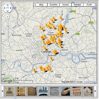
This free application offers some of what I’m looking for, allowing my own geotagged Flickr photos to be easily plotted on a map.
When you click on any image in the bar at the bottom or pin in the map you get a direct link to the Flickr photo and any information given in the photo description (see below). This is a good starting point for a platform.
However, it needs to be able to pull images from a Flickr group rather than a single user and also to aggregate groups of photos from the same location/of the same sign. Also, building in some functionality like that available on this site to suggest geotags for other users’ photos would also be beneficial. Finally, the ability to allow others to add information to the photo would help with adopting the Wiki-based approach to building up research.
[Update, October 2020. Dead links have been removed from the above post.]
Related Posts
-

Landmarks Commission Hearing
Debate over this site for a new painted wall advertisement Frank Jump over in NYC, USA recently presented the case, on behalf of Colossal Media, for the ‘overwriting’ of an old fading ghost sign with a new Colossal production. Presumably an application to do so is under consideration and the Landmarks Commission are deciding whether […]
25 Dec 2007
-
Ghost Signs Live
Browsing Frank Jump‘s blog from USA I came across this great photo by Frank of some sign writer’s (Wall Dogs in USA) putting the finishing touches to a massive brickad. This is clearly for a current business (there’s a web address featured) and is part of the revival happening across the pond. There was also […]
16 Jul 2007
-
Faux ghostsigns
Sometimes hand painted signs on buildings are created to look old and weathered intentionally. The example pictured (original photo on Flickr) was produced in 2003 for the Disney film, ‘Miracle’. (Does anyone have a clip showing where and how it features in the film?) Another Disney example is this sign for the ‘New Orleans Trading […]
1 Jul 2012